 Norsk
Norsk
The Arc of Meridian ExpeditionBy Jørn Henriksen, Kristin PrestvoldDuring the 19th century lots of scientific resources were directed towards utilizing and testing Newton’s notion, presented in his book Philosophiae naturalis principia mathematica in 1687, that the Earth is flatter at the poles. In 1743, Alexis Claude Clairaut published Théorie de la Figure de la Terre, in which he confirmed Newton’s idea. 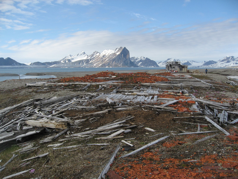
Edward Sabine established a pendulum observatory on Norskøya, Svalbard, in 1823. Historically, pendulums were used to measure the acceleration of gravity in geophysical surveys. The establishment of the Sabine Observatory was based on the reasoning that Svalbard was the perfect platform for investigating the shape of the Earth. In 1826 Sabine suggested that measurements of meridians (lines of longitude through the poles) should be carried out in Svalbard, but it would take almost three quarters of a century before the Swedes and the Russians realized Sabine’s vision. The Swedish–Russian Arc of Meridian Expedition was carried out during five summer seasons and one winter season, which was much longer than planned. The delays were mainly due to difficult ice conditions in the Hinlopenstretet. The measurements were obtained by a set of triangulation points placed on mountain tops, forming a long chain. If the length of the segment of the meridian measured at one interval of latitude was longer than the length of a segment at an equal interval further south, it indicated that the Earth was flatter towards the poles. In Svalbard, the triangulation chain reached from Vesle Tavleøya (one of the islands in the Sjuøyane archipelago) in the north to Keilhaufjellet in the south, spanning a latitudal arc of 4° 13´. The Swedes were responsible for the northern part of the triangulation chain in Svalbard. Their main station was situated at Crozierpynten in Sorgfjorden. There, they established a baseline as a reference for the northern part of the triangulation chain – hence the name Basissletta (the baseline plain). The Russians were in charge of the southern part of the triangulation chain. In August 1899 the Swedes put up a cairn 3.5 m high at one of the mountains of Chydeniusfjellene, which the Russians at Kapp Lee managed to take a bearing of. But it took almost two years until they had completed the whole triangulation chain, with reliable measurements. The cairns along the chain can still be seen today, and are now cultural remains. The two stations used by the expedition are in bad repair, but they still bear witness of the lengthy tradition of research in Svalbard. The Norwegian Helmer Hanssen overwintered as field assistant with the Swedish part of the expedition in Sorfjorden in 1899-1900. Twelve years later he joined Roald Amundsen’s South Pole team. Another Norwegian, Hans Christian Andersen Frænkel, also participated in Sorgfjorden as an engineer. He was the brother of Knut Frænkel, who had disappeared in 1897 with the Andrée balloon expedition bound for the North Pole. Hans Christian was also the godson of the celebrated Danish writer Hans Christian Andersen. Updated May 2015 |
The Cruise Handbook is also available in book formHard cover with numerous pictures - 249 pages - NOK 249.00 Norwegian Polar Institute |