 Norsk
Norsk
Svalbards geological developmentBy Winfried DallmannFor more than a hundred years, Svalbard has fascinated people with a special interest in the geological history of the Earth. Many who have visited Svalbard have been taken with the stark wilderness of the archipelago and its stunning mountains. The diverse geology of Svalbard has resulted in a wide range of landscapes. Hornsund, for example, is surrounded by jagged mountain ridges; the east coast of southern Spitsbergen is characterized by flat-topped nunataks, whereas the landscape around Woodfjorden is distinguished by gentler slopes with distinctive, reddish colours. 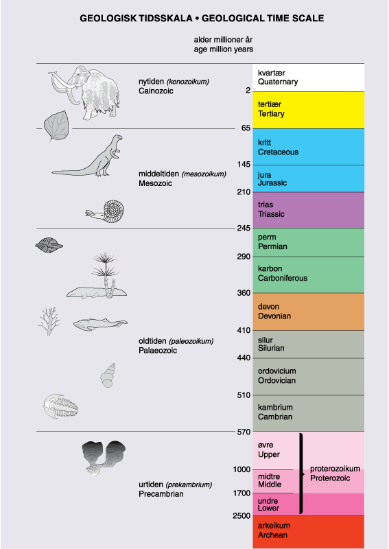 No other place in northern Europe displays such diversity in geological formations and no other place has so many geological eras exposed in outcrops. Since many areas lack significant amounts of soil and vegetation, the bedrock exposures can be studied unimpeded over large distances. All of these factors make Svalbard a unique place for studying geological processes – or for being captivated by the beauty of the land. Evolution through the agesThe often heard statement that Svalbard once was located near the Equator is only partly correct. In Svalbard – as in Norway and the rest of the world – there are rocks that were formed in other climate zones, for instance in the tropical zone during the Devonian. Continental displacement (driven by convection currents in the lower part of the Earth’s mantle) and displacements of the Earth’s surface with respect to its rotational axis (and consequently the North and South Pole) are the most important factors that explain the present-day occurrence of these rocks in the Arctic. However, Svalbard was not Svalbard at that time. When Svalbard’s Devonian rocks were deposited, about 410-360 million years ago, much of Svalbard’s bedrock was not yet there. The other part of what can be seen at the surface today was deeply buried below the surface. It would therefore be misleading to say that Svalbard has moved through the climate zones. Even though the deeper parts of the bedrock basement have been the same since the Devonian, tectonic processes like subsidence and uplift, deposition and erosion, have significantly altered the geographical conditions. (This refers, for instance, to the distribution of land and sea, topography and relief.) At some times during Svalbard’s geological history its rocks were part of an enormous landmass; at other times they were below the bottom of the sea. The history prior to the Devonian is even more complicated, because the basement consists of several blocks of the Earth’s crust, which are derived from places thousands of kilometres apart. These were thrust together during a number of orogeneses (episodes of mountain chain formation) through the Precambrian and the lower Palaeozoic. Svalbard’s geological succession is usually subdivided into three main units: the old basement (Precambrian and lower Palaeozoic); unaltered sedimentary rocks (late Palaeozoic to Tertiary); and young unconsolidated deposits (Quaternary). 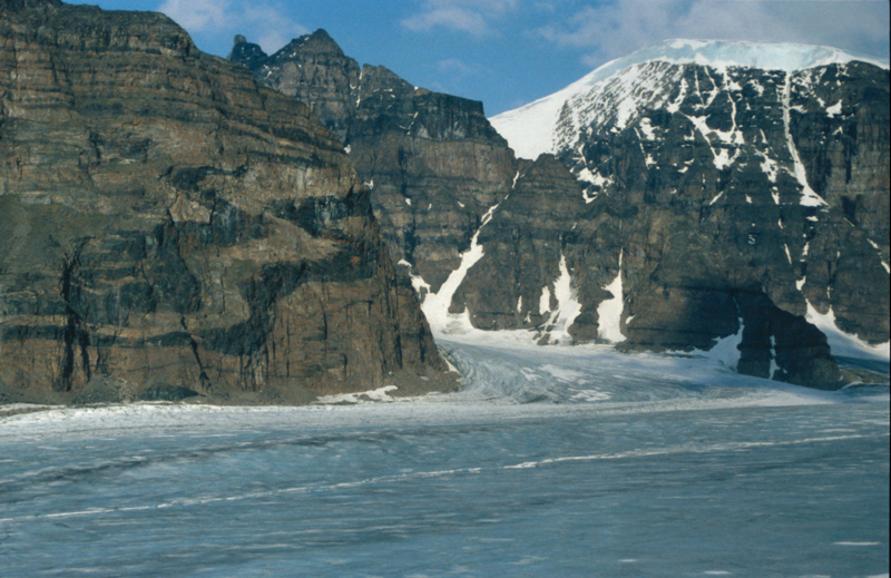
Basement rocks (Precambrian and Palaeozoic up to Silurian)The basement rocks make up the oldest bedrock. The term “basement” is used differently in various countries. In Svalbard we use “basement” for those rocks which were present when the Caledonian orogeny (episode of mountain chain formation) ceased, about 410 million years ago. The last global orogeny phase –which affected all of Svalbard – occurred during the Silurian and gave rise to the Caledonian mountain chain, which reaches from Svalbard through Scandinavia to Scotland and onward to the Appalachians in North America. The counterpart is situated along Greenland’s eastern coast, which at that time was connected to northern Europe. These basement rocks have normally suffered strong movements and alterations. They were folded, displaced along faults, and partly metamorphosed (chemically altered under high pressure and temperature) at depth. Those which lie at the surface today may have lain as deep as 20 km below the surface at that time. During the Silurian and Devonian, when the Caledonian mountain chain was uplifted, large portions of the basement came to the surface, while overlying rocks were removed by erosion. The basement consists mostly of metamorphic rocks like gneiss, crystalline schist, quartzite and marble. Igneous rocks (rocks which were crystallized from magma or lava) also form part of it, for instance, granite, which intruded the upper Earth’s crust during the uplift of the mountain chain. The highest mountain of Svalbard, Newtontoppen, consists of such resistant granite. Some of the younger basement rocks were never subsided deeply, so that no metamorphism took place; they have preserved their original characteristics as depositional or volcanic rocks. The strongest metamorphosed rocks are found in north-west Spitsbergen and in the northern part of Nordaustlandet. The older parts of the basement have suffered several former episodes of folding and metamorphism, and the traces of the oldest ones are almost obliterated. 
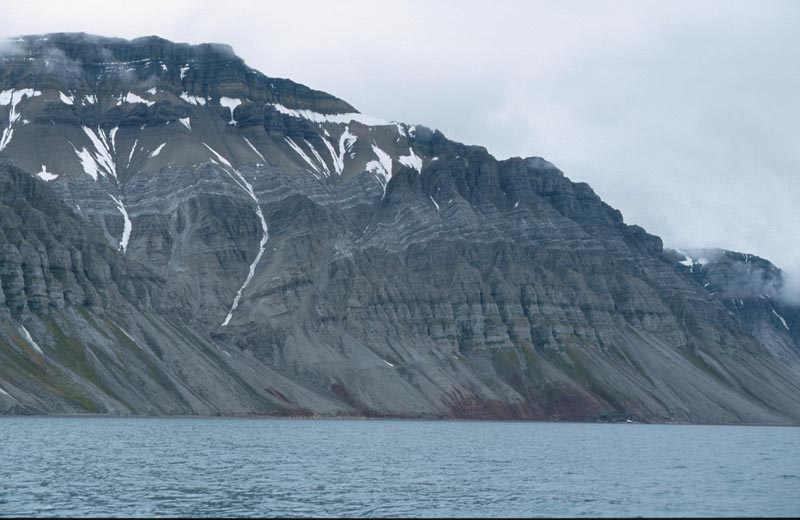
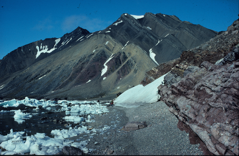
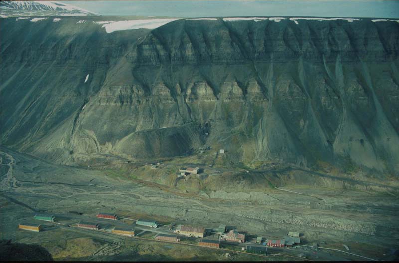
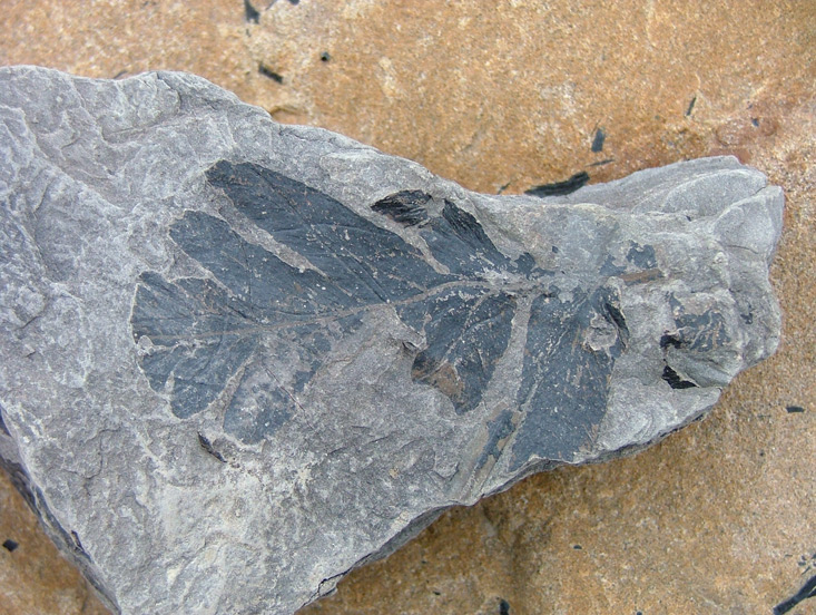
Sedimentary rocks (Devonian to Tertiary)The eroded parts of the mountains yielded vast amounts of sand, gravel and mud that were deposited during the Devonian, about 410-360 million years ago, on river plains and in the sea. The several kilometres thick, red and greenish-grey sandstones of Andrée Land in northern Spitsbergen are formed by such deposits. Later the land was covered by the sea and marine sedimentary rocks were formed. These periods were interrupted by shorter intervals of land uplift above the sea level. Such up-and-down movements resulted in distinct characteristics of the geological record in the sedimentary succession. The rock layers are quite different due to the climatic, geographical, relief and other conditions that changed through time. The distinctly layered, fossil-rich limestones and dolomites with intercalated layers of gypsum and anhydrite of Carboniferous and Permian age (360-245 million years old) in northern and eastern parts of Isfjorden are perceived by many as especially beautiful. These layers were deposited on a continental shelf that formed across most parts of Svalbard after much of the Caledonian mountain chain was eroded (pulled down). The various bedrocks reflect the changing landscape elements in time and space. The white gypsum and anhydrite layers, for instance, are derived from temporarily existing salt water lagoons that dried up in the still warm and dry climate, forcing the dissolved sulfates to crystallize out of the sea water. By the end of the Palaeozoic, global tectonic movements occurred, when Svalbard again became dry land for a short time. It was part of a major, continuous continent, the Pangaea, of which northern Europe, Greenland and North America formed parts. Deposits of Mesozoic age (251-65 million years old) recorded a more moderate climate. Climate and vegetation were initially comparable to the Mediterranean of today and became gradually boreal (northern). Most of Svalbard was again covered by the sea, apart from short interruptions. However, no orogenies did occur. The Svalbard area was often a shallow sea. The closest coast was situated to the west, where there were still remains of the Caledonian mountain chain. Behind these mountains was the Greenlandic Shield. Rivers running down from that mountainous area delivered a lot of debris, which was deposited in the Svalbard area in large river deltas and on the sea floor. Sand, gravel and mud accumulated in this way and can now be seen in the Mesozoic sandstones and shales, which make up large parts of central and eastern Svalbard. Islands, where dinosaurs like iguanadons lived, existed temporarily in the sea. The sea was inhabited by plesiosaurs and ichthyosaurs, giant predatory marine reptiles. During the Cretaceous period the Earth’s crust cracked. A rift system formed within the Pangaea, all the way from the southern to the northern Hemisphere. This was the beginning of the formation of the Atlantic Ocean. Molten rock masses (magma) came up and intruded fissures in the crust. These form a resistant, igneous rock type called dolerite, which can be seen in many places in Svalbard, mainly in layer-parallel dikes (sills), often forming mountain plateaus, ridges, islands and so on. Lava rocks on Kong Karls Land are evidence of volcanic eruptions at that time. The formation of such rift systems often goes hand in hand with land uplift, and during the late Cretaceous all of Svalbard was a land area. During the early Tertiary (60-40 million years ago) the rift system developed into an ocean-spreading system. The north-western corner of the European continent, with Svalbard and the Barents Sea, was slowly cut off from north-eastern Greenland along an enormous transform fault line. During this process the western part of Spitsbergen was folded to form a new mountain chain. It was much smaller than the old Caledonian one, and without the formation of metamorphosed rocks, although large thrust slices were formed that were transposed eastwards onto the Mesozoic rock succession. These thrust slices, or thrust nappes, can be seen in many mountainsides in Wedel Jarlsberg and Oscar II Land, for instance, in Mediumfjellet (Isfjorden), Berzeliustinden (Bellsund) and Scheteligfjellet (Ny-Ålesund). East of the new mountain chain, from the Isfjorden area and southward, the land surface subsided and formed a large, north-south directed bay or strait. It accumulated eroded material from the mountains, now preserved as Tertiary sandstones and shales. At times during this period, conditions were favourable for the formation of coal deposits, when the tectonic movements resulted in slow, periodical flooding and regression of the sea. Today, this subsided area forms the so-called Central Tertiary Basin, a trough structure with the youngest, Tertiary layers in the middle and the oldest layers at the margins. In the middle part of the Tertiary a new phase of volcanism occurred in the entire North Atlantic region that also affected Svalbard. Lava flows are preserved in Andrée Land, where the resistant basalt lava forms mountain tops and plateaus. When the volcanoes erupted, these lava flows ran along valleys and spread into lowlands. Later erosion of mainly the less resistant surrounding sandstones led to an inversion of the topographic relief, with the hard basalts now forming mountain tops. 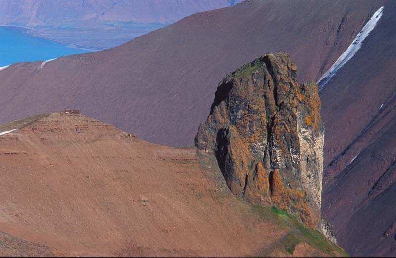
Unconsolidated deposits (Quaternary)The youngest deposits are those of Quaternary age, which started about 2 million years ago and extends to the present time. The bulk of these deposits is unconsolidated and was formed during and after the last ice age: moraines, river deposits, coastal deposits, rock fall deposits, landslides and block fields. During the entire Quaternary period Svalbard has been situated within the polar zone and was subject to glaciations many times. The Quaternary was the first period since the Permian (approximately 245 million years ago) to experience real ice ages, when large ice caps formed on the continents of the northern and southern polar areas of the Earth. Altogether, six major glaciations, lasting between 30 000 and 300 000 years each, have been recorded in the Arctic and the alpine mountain areas of Europe. During the interstitials (warm periods between glaciations), which lasted approximately as long as the ice ages, Svalbard was partially free of ice and significantly warmer than today. But even during the glaciations there were ice-free mountain tops and coastal sections. Most scientists believe that we are today in an interstitial, meaning that a natural cycle will lead us back to a new ice age within some tens of thousands of years, while the global warming we experience today is a temporary (in geological terms), human-made phenomenon. Heavy ice masses on the surface push down the continent (a process called isostatic subsidence) and relative sea level rise occurs. When the ice disappears, the land rises out of the sea again (isostatic rebound). In Svalbard, the shoreline is now 40 to 80 m lower than it was at the end of the last glaciation. The retreat of the shoreline occurred stepwise. In many places old beach lines and old beach terraces are preserved. These contain fossils and other deposited material that provide information about the climatic development since the end of the last ice age. The melting of the ice about 10 000 years ago happened relatively fast. Within 2000-3000 years Svalbard had a much warmer climate than today (3-4°C higher temperature annual average). Vegetation and fauna resembled that in today’s northernmost Norway. Then it became gradually colder, with a climax in the so-called Little Ice Age, only 450-250 years ago. The subsequent warming was a natural process, while human influence on global warming did not start until the late 1800s. Present geological processes in Svalbard are strongly characterized by the permafrost and the presence of glaciers. Much of the deposition that occurs today is related to the transportation of eroded material in glacial rivers, which depends on the seasonal fluctuations in ice melting. Permafrost is responsible for typical Arctic landforms:
During a period of the Quaternary there was active volcanism in north-western Spitsbergen. The most prominent volcano, Sverrefjellet, is between 100 000 and 250 000 years old. The thermal springs by Bockfjorden indicate that the geothermal gradient – the downward temperature increase – is still high in the area in the aftermath of this volcanic activity. Updated May 2009 |
The Cruise Handbook is also available in book formHard cover with numerous pictures - 249 pages - NOK 249.00 Norwegian Polar Institute |