 Norsk
Norsk
Søraust-Svalbard's history and cultural remainsBy Kristin Prestvold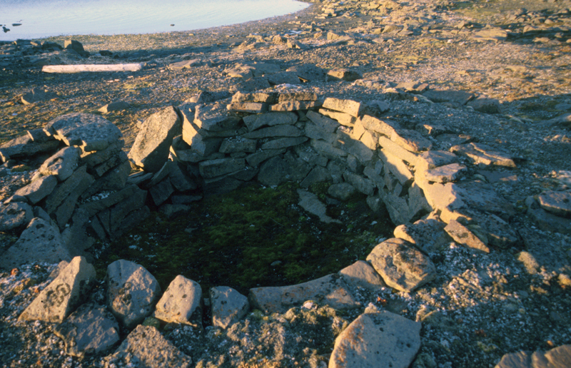
Storfjorden – "the Great Fjord" in Norwegian – was known to the Dutch who first explored Svalbard as Wybe Jansz Water, after the Friesian skipper Wybe Jansz van Stavoren. The name was originally seen on Goo’s map from 1620. Guérard called the fjord Destroict de Jean Suatre in 1628, while Joris Carolus (1634) and many after him called the fjord Wybes Gat. The Russian overwinterers called the fjord Titowa Guba.The fjord was first referred to as Storfjorden in a book by Christie in 1851 (Place Names of Svalbard). Barentsøya can be seen on Van Keulen’s map from 1689 and in all later publications until 1860 as a south-easterly "addition" to Spitsbergen. It was considered a peninsula until Norwegian hunters discovered in 1858 that it was divided from Spitsbergen by a sound. It was later discovered that there were two sounds: Heleysundet in the north and Ormholet in the south of the low peninsula called Kükenthaløya, which is full of cliffs. The discovery of Edgeøya has been attributed to Thomas Edge, in 1616, but the island (or parts of it) was marked on earlier maps. The islands Tusenøyane were mapped for the first time by Joris Carolus in 1614. Valk and Schenk put a number of islands on their map from 1662 and gave them the collective name of Laeg Gebroken Land. It seems to have been Scoresby – an English Arctic explorer in the first part of the 19th century – who was the first to give the islands the name under which they are known today. Lamont, who travelled around Svalbard’s waters between 1859 and 1871, thought the name highly unsuitable as there were not nearly as many islands in reality as would appear on the old maps.
Freebooters of whalingIt did not take many years of ships sailing northwards in the beginning of the 1600s before Edgeøya and its surrounding waters on the east and the west were well known. According to our sources, it was in the area around Edgeøya that the so-called "interlopers" had their main hunting grounds in the first three decades of the 1600s. The interlopers were independent whalers that did not work for the large companies that monopolized whaling. If you did not work for one of these companies, you had no right to be whaling in Svalbard, and really no right to even be in the fjords of the archipelago. One of the most notable interlopers was Thomas Marmaduke from Hull, in England. He is mentioned several times as having been in the waters around the archipelago in the 1600s, either to map resources and coastlines or to hunt whales. Marmaduke travelled to Svalbard frequently as a captain between 1608 and 1619. In 1611 he sailed along the west coast of Spitsbergen, hunting for walrus, and ended up saving the crew and much of the cargo on Muscovy Company’s ships Mary Margaret and Elisabeth, which had both wrecked in Engelskbukta, in the north of Forlandssundet. In 1612 he explored Spitsbergen’s northern coasts and sailed to Gråhuken, where he had to give up because of the ice. In 1613 and 1614 he joined the Muscovy Company. In 1613 he discovered the island of Hopen. It is also believed that it was Marmaduke who discovered Jan Mayen. It was probably these independent whalers – the interlopers – who were the first to carry out whaling in the open ocean as they had to stay away from the main whaling waters the west coast of Spitsbergen for many years. It was probably also these people who perfected the technique of flensing the whale at the side of the ship. The waters by Edgeøya were probably the main area for the freebooters. In the 1640s whaling monopoly rights were taken away and the competition was opened up to everyone. There are several remains of whaling stations along the west coast of Edgeøya. Some of these are rather special as it appears the blubber ovens were never used. The ovens have been built very carefully, and are solid, which makes it even stranger they were never used. But unused, solid blubber ovens survive the centuries very well, and they still look almost as good as new. In Habenichtbukta lies a great whaling station, with a younger Russian hunting station built inside. The whaling station is probably of English origin. The islands Zieglerøya and Delitschøya also have well preserved blubber ovens and cultural remains from the hunting of walrus. The island Halvmåneøya was also visited during the whaling days of the 1600s and 1700s. On the island, north of the station, there is an old burial ground from the whaling period. Nearby is a disused self-firing gun trap and a slaughtering site for polar bears dating from more recent times. The environmental authorities have put a ban on landings and traffic in Habenichtbukta, Zieglerøya, Delitschøya and on Spekkholmen.
Russian overwintering huntingEdgeøya and Tusenøyane were among the main areas for the Russian hunters who overwintered between 1700 and 1850. On almost every island in Tusenøyane there are traces of the Pomors in the form of remains of Russian sites, graves, foundations and remains of Russian crosses and slaughtering sites for walrus. Some of Svalbard’s largest hunting stations from the Russian hunting era can be found along the east coast of Edgeøya. Today the stations are in ruins, but they are still visible in the landscape. The remains of a Russian site situated inside the area of the earlier whaling station in Habenichtbukta is one of the largest Russian sites in Svalbard. Written sources from 1827 describe the station as still being well preserved, and it is believed that the hunting here was carried out almost up until that time. The whaling station and the Russian site in Habenichtbukta are highly prioritized cultural remains. Ekrollhamna lies a little north of Habenichtbukta. It is a safe and good port, where the remains of another one of the really large Russian hunting stations can be found. Excavations that have been carried out here indicate that the early settlements of the Pomors in Svalbard took place here. There are traces of several Russian hunting stations along the west coast of Barentsøya. The environmental authorities are contemplating restrictions on traffic in Habenichtbukta and in Ekrollhamna.
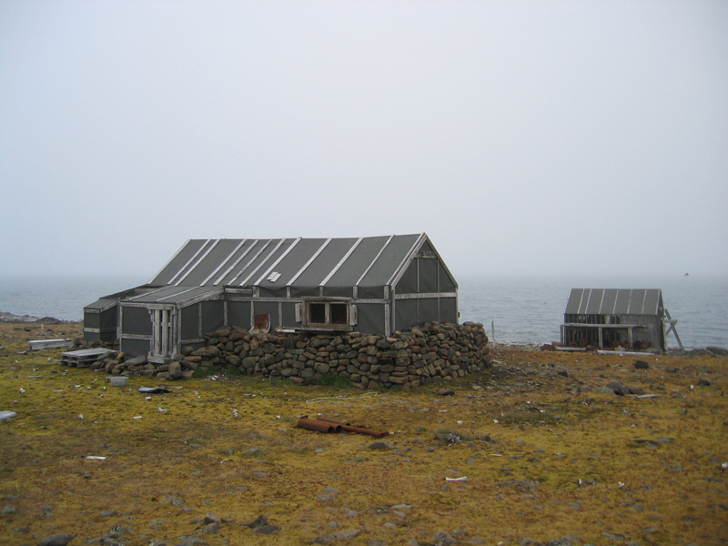
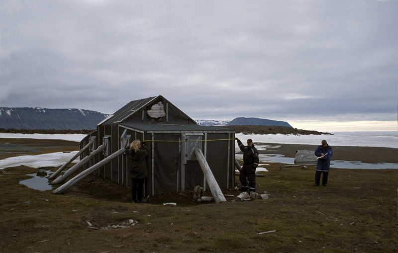
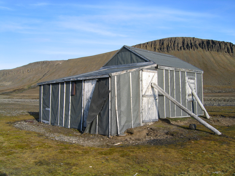
Norwegian overwintering huntingThe Norwegian overwintering hunting has also left many remains in this area of Svalbard. The most famous and most visited Norwegian hunting station is perhaps Bjørneborg, on the island of Halvmåneøya. Its history goes back to 1898. Bjørneborg’s main building dates from 1904. It was added to in 1935 and 1963. The cabin was restored in 1995, and the station was restored to what is believed to have been its appearance in 1935. The area was the best bear hunting grounds in Svalbard. Bjørneborg well illustrates how a recent bear hunting station was. The station is very complete, and self-firing gun traps are found both out in the terrain and in the storage building. The last season in which the station was in use was in the winter of 1969-1970. In the area several loose objects from the time when the station was in use can be found. These tell us much about what happened there. The cultural remains – especially the large number of objects – are very vulnerable to being stepped on, touched and taken for souvenirs. No-one must remove anything from this place. The environmental authorities have put a ban on landings and traffic on Halvmåneøya, except for a small area around Bjørneborg. Other cabins used by Norwegian hunters are one located at Kapp Lee/Dolerittneset, on the north-western point of Edgeøya, and Villa Disko, situated in the north of Diskobukta further south on the west coast. Villa Disko was built in 1929 by Georg Bjønnes and the brothers Einar and Eldor Svendsen. The cabin was the main station; satellite stations were established further south in Diskobukta and in the north-east of Edgeøya, by Kapp Heuglin. Next to the old cabin there is a newer structure, built by the Norwegian Polar Institute. At the point of Andréetangen on Edgeøya, by Zieglerøya and Delitschøya, there is a cabin that was built by Henry Rudi in 1946. There are a number of cultural remains by the cabin, such as a small slaughter site for walrus. On the northwest side of Barentsøya, on Frankenhalvøya, is Heimland. The cabin is a Merckoll cabin: the same type that was built by mine superintendent Merckoll in 1936 in Isflakbukta on Phippsøya, Sjuøyane. The cabin was one of several emergency cabins that were built in the east of Svalbard that year to provide shelter to people in need, for example, when ships went down. The cabins were paid for by the government. Apart from these, there are many other remains of hunting stations associated with Norwegian overwintering hunters on the islands in this area. There are graves as well. The environmental authorities are contemplating restrictions on Zieglerøya and Delitschøya. Guidelines for visitors by Association of Arctic Expedition Cruise Operators (AECO)
Updated June 2015 |
The Cruise Handbook is also available in book formHard cover with numerous pictures - 249 pages - NOK 249.00 Norwegian Polar Institute |