 Norsk
Norsk
Bellsund's geology and landscapeBy Jørn Henriksen, Winfried Dallmann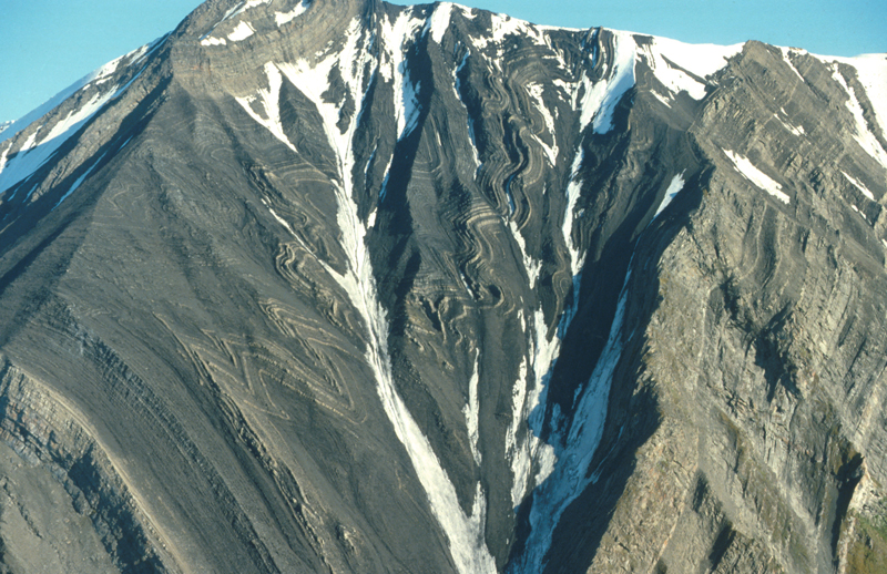
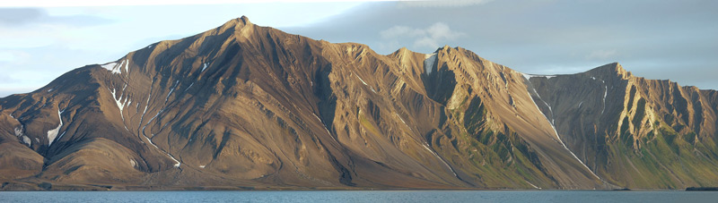
This chapter includes Bellsund, Van Mijenfjorden, Van Keulenfjorden and Recherchefjorden. Bellsund is a wide fjord that splits into two branches approximately 20 km from its entrance. Recherchefjorden stretches south-west from the entrance of Van Keulenfjorden. The name Bellsund is derived from the bell-shaped mountain Klokkefjellet on the southern shore, by the entrance to the fjord. Wide coastal flats surround the fjord system, forming an open landscape. There are no glaciers that calve into Bellsund; one must travel into one of Bellsund’s two eastward branches to see glaciers that terminate in the sea. The border of Sør-Spitsbergen National Park follows the mid-line of Van Keulenfjorden and Bellsund: all landings on the southern shores of these fjords are inside the park. The land around Bellsund, Wedel Jarlsberg Land in the south and Nordenskiöldland in the north, shows signs of the enormous forces in action when the European continental plate was pushed against Greenland in the transition between the Cretaceous and the Tertiary (about 50-60 million years ago). The faults are quite dramatic in the border areas between Van Mijenfjorden and Bellsund and can best be viewed up close if you land in Vårsolbukta or at Ahlstrandodden. The formations can also be seen from deck when approaching the landing sites described for this area. Further into Van Mijenfjorden and Van Keulenfjorden there are more or less horizontal layers of Tertiary sedimentary rocks, seemingly unaffected by the faults on the west coast. Geologists refer to this area as the Tertiary Central Basin. In Sveagruva (the Svea mine) coal is extracted from a several metre thick coal seam dating back about 65 million years ago, when great quantities of carbon, in the form of dead plants and trees and other organisms, were laid down. In eastern Bellsund there is a distinct mountain range that divides Van Mijenfjorden and Van Keulenfjorden. This peninsula is a part of Nathorstland, which stretches west to Midterhuken. The western summit is called Gåsberget. From Mariasundet on the north side of Midterhuken you can observe the impressive folds – at some places visually underlined by lush, green vegetation fertilized by nesting Brünnich’s guillemots and kittiwakes. The fjord ice breaks up relatively late in Van Mijenfjorden and Van Keulenfjorden, some years there is still ice in June. The little island of Akseløya acts as an effective stopper – obstructing both the fjord ice that exits the fjord in spring and the ice that drifts into Bellsund from the sea outside. Akseløya is a striking part of the landscape. Stratified rock formed in the upper Permian period tilt up almost vertically, dominating the island,. The bedrock is comprised of marine deposits containing flint. The Governor of Svalbard organized a search for human-modified flint on the island in 1998. This was to check the theory of Stone Age cultures in Svalbard, similar to that of other comparable high latitude sites. They found lots of flint but nothing that had been shaped by means other than natural weathering, giving no support to the Stone Age theory. Similar flinty Permian folded strata are found at Ahlstrandodden. Updated April 2015 |
The Cruise Handbook is also available in book formHard cover with numerous pictures - 249 pages - NOK 249.00 Norwegian Polar Institute |