 Norsk
Norsk
Bellsund's history and cultural remainsBy Kristin Prestvold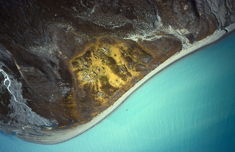
The area was named Klock Bay by Jonas Poole in 1610 and was probably frequently visited by whalers during the early 17th century. Through history the three fjords have carried different names. Van Mijenfjorden was originally called Lowe Sound by Poole. Van Keulenfjorden was given the name Sardam Bay – Fotherby called it Lord Ellesmere Sound in 1613 and it was placed on the Goos map of 1620. The small fjord today called Recherchefjorden was prior to 1838 known as Schoonhaven or Clean Bay amongst whalers (Willem van Muyen 1612). For almost two centuries, from the beginning of the 17th to the end of the 18th, Recherchefjorden was one of the most popular assembly areas for the whaling fleet. Today’s name reflects the French Recherche Expedition that visited the area for two weeks during the summer of 1838. The history of Bellsund starts with the whaling at the beginning of the 17th century. It continues with Russian overwintering trapping in the 18th century and with Norwegian overwintering trapping and mining at the beginning of the 20th century. Coal-mining is today operated by Store Norske Kullkompani in Svea. At Akseløya old trapping traditions are being kept alive. 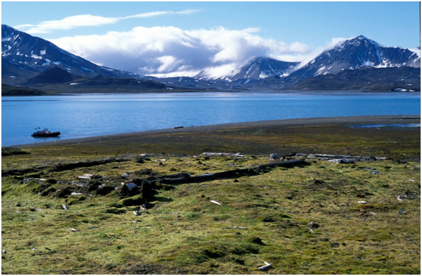
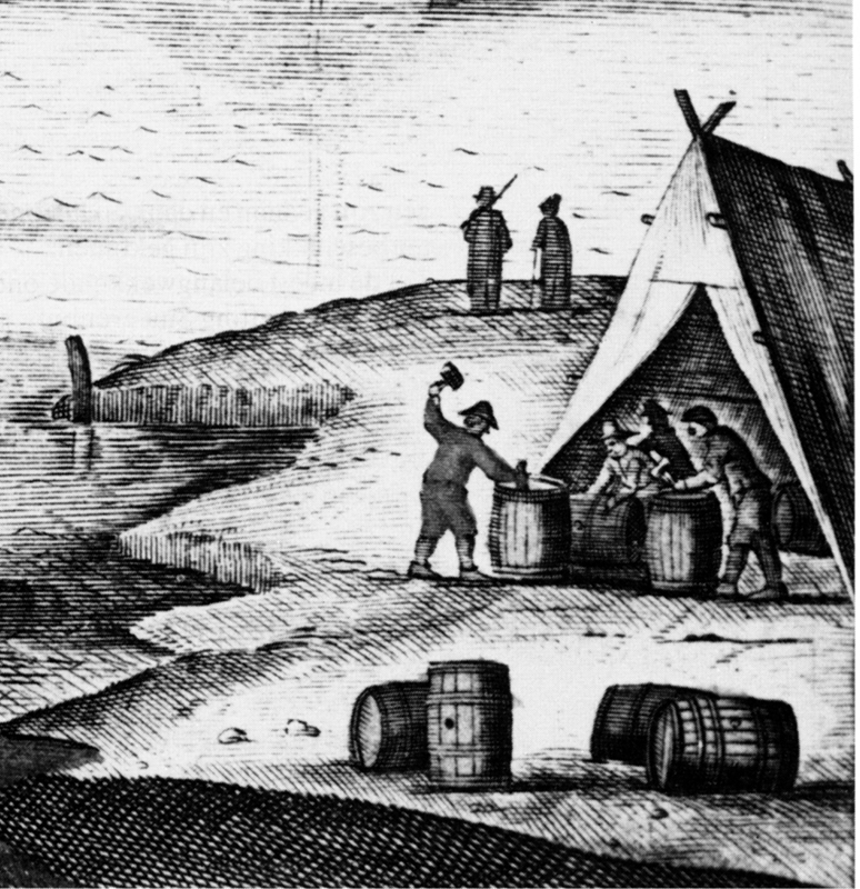
Tomtodden, there are remains of the well-known Russian Cicagov Expedition in 1764-1766 – a large-scale expedition set out to find a northern passage to the Pacific via the strait between Svalbard and Greenland (later given the name Framstretet or Fram Strait). The ambitions were never fulfilled. Tomtodden was used as a base for the two overwinterings by the expedition. The cultural remains comprise sites of dwelling houses, sauna and storage. There are also at least five foundations for Russian orthodox crosses and substantial amounts of waste. The crosses at Tomtodden can be seen in an illustration from the Recherche Expedition in 1838. The buildings are also shown in a panorama (illustration) from the same expedition. 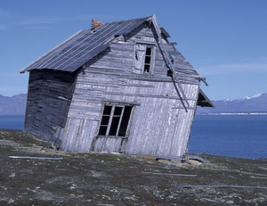
At the point of Snatcherpynten you find Camp Smith, also called Giæverhuset, which is Svalbard’s equivalent to the Leaning Tower of Pisa. The house was erected by Consul Johannes Giæver from Tromsø – allegedly as his summer house. The building is today very crooked and in bad repair, but well documented. The Governor of Svalbard has carried out some repairs to prevent it from falling down. At the same location there are also remains from a whaling station and a small burial ground. On a ledge a few hundred metres above the summer house, the grave of Trygve Olsen from Tromsø is found – he died during an overwintering here in 1914. Close to the beach there is quite a lot of mining equipment that once belonged to the Northern Exploration Company Ltd. (NEC). NEC bought the place in 1911 for unclear reasons, since there are no mineral seams here. It could be interpreted as a demonstration of NEC’s position of power in the Bellsund area, where they occupied and bought properties everywhere with a slight chance of finding mineral deposits. In Bellsund NEC prospected for minerals ranging from iron and coal to asbestos and zinc. They were highly optimistic in their prospects and trial operations – quite typical of their times – but the actual production was close to nothing. A Klondike-like fever for minerals prevailed in Svalbard then, and any area that could possibly hold mineral deposits was quickly annexed. Lægerneset is located on the eastern side of Recherchefjorden, and the whaling station here is one of the largest from the 17th century. Blubber ovens, lookouts and other sites are found here. On a hill behind the station lies a burial ground. The whaling station is beautifully located in between natural cliffs used as components in the construction. Several tall stone walls are easy to make out. The station was established in 1612 by Dutch whalers and later taken over by the English, who called the place Edges Point. The station was left around 1640. This is probably also where the first (involuntary) overwintering in Svalbard took place, from 1630-1631. Eight British whalers, including Edward Pelham, were lost from their mother ship in a storm and had to spend nine months in Bellsund until they were rescued by a British ship. Signs of NEC activity in the early 20th century can be seen inside the whaling station. Lægerneset has a high cultural and historical value, but it is prone to natural weathering as well as wear and tear from visiting tourists. Updated March 2015 |
The Cruise Handbook is also available in book formHard cover with numerous pictures - 249 pages - NOK 249.00 Norwegian Polar Institute |