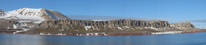
 Outside the lateral moraines west of the glacier Kongsbreen in Kongsfjorden. From left to right is seen the mountains of Collethøgda, Dana (the southernmost of the Tre Kroner peaks), Pretender and Dronningfjella. (Image: Mats Hjelle / The Governor of Svalbard)
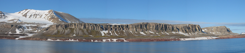
 The bird cliff Stuphallet, west of Ny-Ålesund. The underlying reddish sandstone is evident at the bottom, along the shore. (Image: Kristen Fossan / The Norwegian Polar Institute)
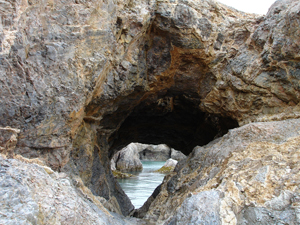 Marble with dolostone passages on the island of Blomstrandhalvøya. During thousands of years the sea has carved out caves in the bedrock. (Image: Lise Øvrum / The Governor of Svalbard)
 Overview picture taken from the north side of Kongsfjorden. Blomstrandhalvøya has now become an island because of the retreat of the Blomstrandbreen. In the background is Brøggerhalvøya and – far out – Prins Karls Forland. (Image: Geir Wing Gabrielsen / The Norwegian Polar Institute)
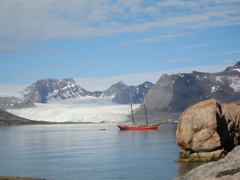
 Blomstrandbreen viewed from the island of Juttaholmen. The mountain Løvlandfjellet is seen in the background, and Feiringfjellet on the right side. (Image: Geir Wing Gabrielsen / The Norwegian Polar Institute)
 Conwaybreen calving into the sea, innermost in Kongsfjorden. (Image: Geir Wing Gabrielsen / The Norwegian Polar Institute)
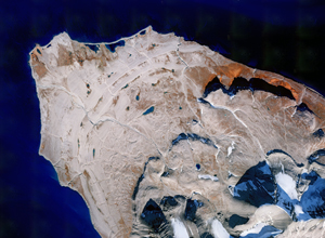 Satellite image of Kvadehuksletta and outer parts of Brøggerhalvøya. The raised beach deposits are seen clearly in the picture. Kongsfjorden is at the top of the picture. At the top right lies the bird cliff Stuphallet. The lush areas beneath the cliffs appear red-brown in colour. (Image: The Norwegian Polar Institute)
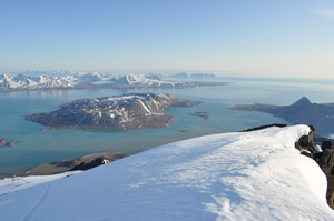
 View from the mountain Kronprins Olavs fjell over Möllerfjorden to the south and towards Krossfjorden. The island of Prins Karls Forland is seen in the background. The peninsula Kong Haakons Halvøy is on the right. (Image: Mats Hjelle / The Governor of Svalbard)
 Innermost in Lilliehöökfjorden is situated the great glacier Lilliehöökbreen, which calves into the sea. The seven-kilometre wide glacier front gives a mighty impression. The glacier is a so-called ice stream originating from central parts of Albert I Land. (Image: Mats Hjelle / The Governor of Svalbard)
 The mouth of Möllerfjorden. The bird cliff Kongshamaren is to the left. Also seen are mountains on the eastern side of Möllerfjorden. (Image: Jørn Henriksen)
The Kongsfjorden area is located on the west coast of Spitsbergen at 78° 45' N to 79° 20' N. The area encompasses the sound of Forlandsundet north of Sarstangen, the fjords Kongsfjorden and Krossfjorden, including the fjord arms Möllerfjorden and Lilliehöökfjorden. The western part of Forlandsundet is part of Forlandet National Park, and Krossfjorden and the surrounding area lie within the Nordvest-Spitsbergen National Park. Additionally, four natural reserves are located within the area. (See Chapter 1 for further description of the protected areas in Svalbard.)
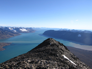
The area of Kongsfjorden and Krossfjorden boasts magnificent natural scenery. The spectacular mountain formations reflect different geological periods. The island of Brøggerhalvøya lies within an area along the west coast of Svalbard, which is characterized by abundant thrusts that formed in the early Tertiary when Greenland was pressed obliquely against Svalbard The result is that layers of older bedrock lie on top of younger strata. This can, for instance, be seen at the northern foot of the mountain Zeppelinfjellet. The mountain peaks at the south side of inner Kongsfjorden, and towards the glacier Uvêrsbreen, are also composed of older crystalline rocks. The bedrock in this area is composed of phyllite with embedded quartzite layers, mica schist and marble. The nunataks surrounding the innermost part of of Kongsfjorden are composed of younger sedimentary rocks from the Carboniferous and Permian. The pyramidal peaks of Tre Kroner are among the most conspicuous, with horizontal Carboniferous layers on top of weakly folded Devonian layers. The bedrock on the westernmost tip of Brøggerhalvøya is distinguished by thrust tectonic.
Reddish sandstone derived from desert sand crop out beneath the bird cliff Stuphallet between the headlands of Brandalpynten and Kongsfjordneset, and also present around the Brøggerbreane glaciers just south of Ny-Ålesund. The sand was deposited when Svalbard was located at the same latitude as the North African deserts today. Erosion of the sandstone produces fine-grained material that causes red-coloured glacial streams in this area.
The north side of the fjord is dominated by metamorphosed basement rocks such as marble and mica schist. A wide belt of marble and dolostone stretches from the island of Blomstrandhalvøya and northwards, perforated with small caves and holes. These features are typical of so-called karst landscape, where the lime (marble is metamorphosed limestone) is being dissolved by groundwater.
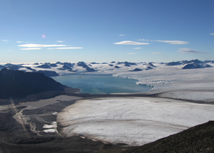
Standing on a boat deck in Kongsfjorden there are great views of high mountains and huge glaciers surrounding the fjord. The island of Blomstrandhalvøya, which is situated in the middle of the fjord, was considered as a peninsula before the retreat of the glacier Blomstrandbreen in the 1990s.
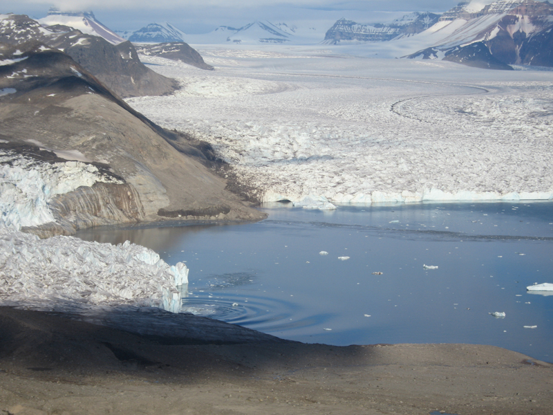
The research community and settlement of Ny-Ålesund is situated on the south side of the fjord, opposite to Blomstrandhalvøya. At the head of the fjord, four large glaciers reach the sea: Kongsbreen, Kronebreen, Kongsvegen and Conwaybreen. Visitors are occasionally fortunate enough to experience one of the glaciers calving loudly into the sea, creating huge swells.
The peninsula of Brøggerhalvøya, at the south side of Kongsfjorden, is a mountainous landscape with peaks of 600-800 metres and seven glaciers, all terminating on land. Kvadehuksletta is located furthest west on Brøggerhalvøya. A vast strandflat, it contains several old and raised shore deposits seen as low ridges in the landscape. Some of the deposits were formed 130 000 – 290 000 years ago, while the terraces were formed during a gradual retreat of the coastline following the last Ice Age, i.e., during the last 10 000 years. The coal deposits south of Kongsfjorden laid the ground for mining in Ny-Ålesund, starting in 1920 and lasting until 1962. Following a series of accidents in the mines, a major explosion in one of the mines killed 21 people and put an end to further mining.
South in this area is Forlandsrevet, a reef dividing the sound of Forlandsundet into a northern and southern part. The reef lies at about four metres depth, hindering most of the larger boats from passing through the sound.
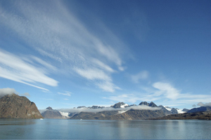
North of Kongsfjorden lies the fjord Krossfjorden, surrounded by high mountains and five glaciers terminating at the sea. Approximately 20 kilometres into the fjord, it divides in two with the peninsula Kong Haakons Halvøy in the middle. Lilliehöökfjorden is the name of the western fjord, and Möllerfjorden the eastern.
Lilliehöökfjorden, with Kong Haakons Halvøy on its eastern side, high, lush mountains on its western side and the great glacier Lilliehöökbreen at the head of the fjord, offers a fantastic panorama. The eastern part of Krossfjorden, including Möllerfjorden, are flanked by mountains cut by glaciers calving into the sea. Möllerfjorden has three side arms – Tinayrebukta, Mayerbukta and Kollerfjorden.
 Norsk
Norsk