 Norsk
Norsk
Sorgfjorden [79° 50' N 16° 30' E]By Øystein Overrein (ed.), Jørn Henriksen, Bjørn Fossli Johansen, Kristin PrestvoldSorgfjorden is situated on north-east Spitsbergen, by the inlet to Hinlopenstretet. It is surrounded by large strandflats. The distinctive mountain Heclahuken is in the south-east. There are good anchorages in Sorgfjorden, protected by Eolusneset in the west and Crozierpynten in the east. 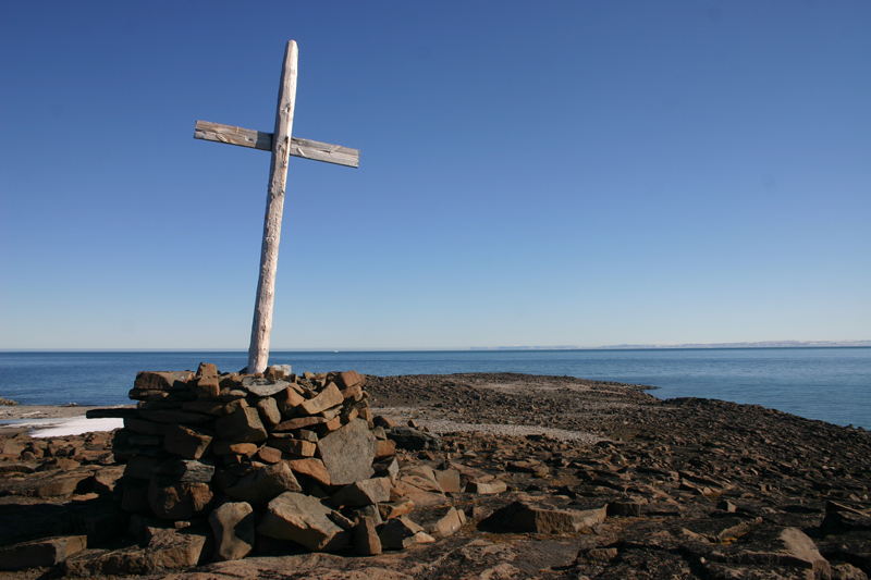
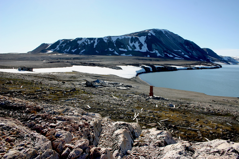
The good ports in Sorgfjorden were known in the 1600s when the whalers sailed around these areas. But Sorgfjorden was also known early on for its difficult ice conditions. The estuary is wide and is situated by Nordporten in Hinlopenstretet. The drift ice can come very suddenly, pushing its way through and trapping ships and crews, offering them no opportunity to escape. Many such stories can be accredited to Sorgfjorden (the fjord of grief). In 1683 13 Dutch whalers experiences the unforgiving nature of the ice. The drift ice came very suddenly, blocked the estuary and trapped them. The whalers had to evacuate their ships and leave all that they had caught through a tough summer of whaling. They dragged the rowboats over the ice to open waters, and rowed along the northern coast of Spitsbergen until they finally reached Smeerenburg, where they were saved by other Dutch whalers, who had not yet left for home at the end of the season. The crew escaped with their lives. But they could not save their valuable cargo. In 1689 a war broke out among the seafaring nations of Europe. There were no rules, and nobody escaped it, not even the whalers in Svalbard. In 1693, the French captain Antoine d’Arcy de La Varenne was given the mission of sailing north to Svalbard and burn and sink all ships that sailed under the flags of the enemy: England, Holland and Hamburg. The catch was to be seized as war booty. Four French frigates set off towards the archipelago and started a raid against all “enemy” whalers in the waters around it. In the end 40 Dutch ships gathered and attacked two of the French frigates in Sorgfjorden. The fight in Sorgfjorden lasted for hours and there was much fire from both sides. The Dutch ships then began to flee the fjord by towing their ships, although difficult to manoeuvre, with their rowboats. They made it past the French, who could not stop them as their own rowboats had been destroyed in the midst of the fire. Despite this, the French managed to trap 13 of the Dutch ships. The French frigates sailed out of Sorgfjorden with 11 whalers as their loot, after having burnt two of the ships. The total number of deceased is not known but it may have been low: one of the French frigates reported two dead. The French claimed untruthfully that they had confiscated all catch from the Dutch in Svalbard that season, and that the Dutch ships that managed to escape returned home with practically nothing. In fact, of the 89 Dutch ships went northwards that year, 26 were taken and six sank in the ice; the rest of the fleet returned with 175 whales – a pretty good catch. Throughout the 1800s and 1900s, Sorgfjorden was visited by scientific expeditions. Parry’s expedition in 1827 is worth mentioning, as well as the Swedish–Russian Arc-of-Meridian Expedition n 1899-1900 and the Schröeder–Stranz Expedition in 1912-1913. By the approach to Sorgfjorden lies Eolusneset, on top of which a cross stands tall. It was raised by skipper C. Holmgren from the schooner Eolus of Bergen, which was trapped by ice here in 1855. According to the inscription on the cross, it was raised in memory of fallen whalers, after the famous sea battle in Sorgfjorden in 1693. The burial ground that lies a little further out on the headland also commemorates this. But something is not quite right here. Parry, who visited Sorgfjorden and the graves in 1827, gave a good description of the graves and the inscriptions that were still legible on the crosses. The inscriptions revealed that the 30 graves have no connection with the sea battle, but were, as were many other coastal areas and beaches along the west and north of Svalbard, a cemetery for 17th and 18th century whalers. The fjord was also visited by Norwegian hunters who overwintered in the 1900s, but the area was not frequently used. In 1921 the Hagerup/Jensen expedition built a secondary station on the plain north of Eolusneset. It was repaired in 1926 by Arthur Oxaas and the Svendsen brothers. It was later said that it was useless. The cabin is still there, almost a ruin. On Crozierpynten there are ruins of installations that the Swedish built at the very end of the 1800s. Swedish and Russian experts got together and carried out a massive research project that stemmed from the question of the exact shape of the Earth – the Swedish–Russian Arc-of-Meridian Expedition. The scientists wanted to determine whether the Earth was flatter at the poles, as Isaac Newton had hypothesized and in support of which geodetic surveys in northern Finland in the mid-19th century had found evidence. Svalbard was chosen as a study area for the Swedish–Russian expedition, which included an overwintering in Sorgfjorden in the winter of 1899-1900. The installations in Crozierpynten were paid for by the Swedish state. The scientists Jäderin, Rubin, Westman, Fraenkel and doctor Torgersruud overwintered together with eight other men in the winter of 1899-1900. Many places in Nordaustlandet have been named after the participants of this expedition. The Swedish left the station in 1900, and nature immediately started its destructive work. The installations were slowly reduced to ruins. One of the houses repaired during a Norwegian overwintering – the Hagerup/Jensen expedition in 1921-22 – and again in 1927 by the Svendsen brothers, is still standing. All the buildings apart from this one have collapsed and lie on the ground. Visitor guidelinesGuidelines by Association of Arctic Expedition Cruise Operators (AECO). Updated May 2015 |
The Cruise Handbook is also available in book formHard cover with numerous pictures - 249 pages - NOK 249.00 Norwegian Polar Institute |